Search This Blog

Showing posts with label Maritime. Show all posts

Tuesday, January 1, 2013

Flustercluck, part deux

The oil rig Kulluk is now aground on Sitkalidak Island, just off of Kodiak AK. Here's a map. Not sure where on the island it's aground.

==========================================

(CNN) -- A Royal Dutch Shell oil drilling barge remained grounded Tuesday on an island off southern Alaska amid a fierce winter storm that hindered recovery efforts, Coast Guard and Alaskan authorities reported.

The Shell-owned rig Kulluk was being towed to Seattle when it began encountering trouble Sunday, the Coast Guard said. One tug needed help after its engines failed; a replacement had to cut the rig loose Monday night during a storm that whipped up 24-foot waves in the Gulf of Alaska.

The 266-foot rig ran aground off Sitkalidak Island, about 200 miles south of Anchorage, on Monday night. A joint command was set up to head off any possible environmental damage, but crews had not been able to confirm the Kulluk's condition Tuesday morning, those authorities reported.

The Kulluk had 139,000 gallons (4,400 barrels) of diesel fuel and 12,000 gallons of combined lube oil and hydraulic fluid on board; no leaks had been detected early Tuesday.

Weather conditions were expected to improve through the rest of the week, with seas subsiding from 24 feet Tuesday to 11 feet by Friday, according to the National Weather Service.

Susan Childs, Shell's incident commander, said more than 250 people were working on the response. The rig grounded in an area of Ocean Bay, where water depth is 32 feet to 48 feet, according to a release from the response team.

The Kulluk is part of Shell's controversial effort to drill for oil in the remote Arctic, a project that caused widespread concern among environmentalists and was held up after BP's Deepwater Horizon disaster in the Gulf of Mexico. It finished drilling operations in October, and its 18-person crew was evacuated Saturday.

The rig was being used to drill in the Beaufort Sea, off Alaska's North Slope. Shell says it's working at far less depth and lower pressures than the BP well that erupted off Louisiana, killing 11 men aboard and unleashing an undersea gusher that took three months to cap.

The U.S. Geological Survey estimates more than 90 billion barrels of oil and nearly 1,700 trillion cubic feet of natural gas may be recoverable by drilling. And the shrinking of the region's sea ice -- which hit record lows in 2012 -- has created new opportunities for energy exploration in the region.

Climate researchers say that a decrease in sea ice is a symptom of a warming climate, caused largely by the combustion of carbon-rich fossil fuels. The science is politically controversial but generally accepted as fact by most scientists.

Sunday, December 30, 2012

Flustercluck.

Outside of the maritime community, this hasn't been getting very much press. It is a mess. ===========================================================

ANCHORAGE DAILY NEWS 30 December 2012 2100ast

An unmanned mobile oil drilling rig owned by Royal Dutch Shell is adrift -- again -- south of Kodiak Island after it lost towlines Sunday afternoon from two vessels trying to hold it in place against what have been pummeling winds and high seas, according to incident management leaders.

A team of 250 people from the Coast Guard, the state of Alaska, Royal Dutch Shell, and one of its contractors was hunkered down Sunday, mainly in Midtown Anchorage's Frontier Building, trying to resolve the ongoing crisis with the Shell-owned drilling rig, the Kulluk.

Before the latest turn for the worse, representatives of the Coast Guard, Shell and the state Department of Environmental Conservation told reporters in a briefing early Sunday afternoon that the situation was critical, but under control.

Then tow lines from the Aiviq and a second support vessel, the Nanuq "separated," the joint command team said in a statement sent out at about 4:30 p.m. The setback happened sometime after 1 p.m., just as commanders were briefing news media on what appeared at that point to be a successful response after a series of failures. They didn't yet know the towlines had broken free, said Shell spokesman Curtis Smith, who is part of the unified incident command team.

A third vessel, the tug Alert, which is usually stationed in Prince William Sound as part of an emergency response system, has arrived on the scene. And a fourth Shell-contracted support ship, the Guardsman, is on location.

"The crew is evaluating all options for reconnecting with the Kulluk," the command team said. Tow lines are still attached to the Kulluk and conceivably could be reattached to the nearby ships, Smith said.

But with its crew evacuated for safety reasons, there's no one on board to tend the winches or maneuver equipment, Sean Churchfield, Shell's incident commander and the company's operations manager for Alaska, told reporters earlier on Sunday.

All decisions, including the evacuation, are being made by the group as a whole, said Capt. Paul Mehler, the Coast Guard's Anchorage-based commander.

The Gulf of Alaska storm has been fierce, with near-hurricane winds on Saturday night, Mehler said. Only a small lull is predicted for Monday morning, according to the National Weather Service. The forecast for Sunday night was 28-foot seas and winds in the range of 50 mph or more, about what it was on Saturday, said meteorologist Bob Clay. Seas and winds are expected to diminish Monday morning, then pick back up later in the day as another storm moves in, he said.

With no towlines securing it in place, the crew-less Kulluk is drifting about 20 miles south of Sitkinak Island, part of the Trinity Islands, south of Kodiak. Smith said early Sunday evening that he had not yet been briefed on how many hours it would take the Kulluk to reach shore if it continues adrift. A number of variables, including currents and wind speed, would affect when and where it hit, if it came to that, he noted. He said he would provide the information when he gets it.

The incident team also must find a safe harbor for the Aiviq, as well as the Kulluk, to undergo inspections and possible repairs before heading south to Everett, Wash., where the Kulluk had been headed for off-season maintenance before the troubles began.

The $290 million, 266-foot diameter Kulluk is a conical-shaped mobile rig that began drilling a single exploratory well in the Beaufort Sea this year. But it cannot propel itself, and a series of failures involving the rig began on Thursday during a stormy Gulf of Alaska crossing.

The 360-foot, $200 million Aiviq is a new ship commissioned by Shell for its Arctic work and built and owned by Louisiana-based maritime company Edison Chouest Offshore.

The Kulluk lost its towline from the Aiviq on Thursday. A second tow line was attached for a time, but then early Friday all four engines on the Aiviq failed. The Coast Guard sent the Alex Haley, a 282-foot cutter. It delivered a towline to the Aiviq, which was still attached to the Kulluk, but the sheer mass of the ship and the drilling rig, combined with 40 mph winds and building 35-foot seas, broke the connection and the line became tangled in the cutter's propeller and damaged it. The Alex Haley turned back to Kodiak for repair, but now is back at the Kulluk scene.

The towline mishaps and the engine failures are under investigation, Churchfield said.

On Saturday, the Kulluk's 18-person crew was safely evacuated to Kodiak in two Coast Guard helicopters. The Aiviq's engines were repaired with new fuel injectors, and the Nanuq, also under contract to Shell, put a towline on the Kulluk, for a time. The Aiviq then was running off two engines at a time, as a precaution, officials said Sunday.

Initial reports suggested that contaminated fuel might have caused the engines to malfunction, but that hasn't been confirmed through fuel analysis, Churchfield said.

"I don't really want to speculate as to the causes of the propulsion failure on the Aiviq," he said. "We are looking for the solutions and we will have a full investigation. At this stage I don't have any firm information to pass onto you."

However, the fuel now being used is from a different tank than that in use when the engines failed, said Shell's Smith.

The plan to use just a single ship to tow the Kulluk was reasonable, given the Aiviq's features, said the Coast Guard's Mehler.

"This type of operation is very normal. With the vessel the size of the Aiviq, with the capabilities of the Aiviq, with four engines, it was above and beyond what would be required to be able to tow, even in very extreme conditions," the commander said.

Shell did not have to get Coast Guard approval of its towing plan, because the maritime operation was so routine. But the oil company did consult with the agency as the vessels began their journey, Mehler said.

At the start of Shell's 2012 drilling season, the Aiviq towed the Kulluk from a shipyard in Washington state to Dutch Harbor and then to the Beaufort Sea, where two tugs took over to handle it, Churchfield said.

Two crew members on the Aiviq suffered minor injuries at some point, but both are back at work, Churchfield said.

No oil has been spilled during the incident, according to the state Department of Environmental Conservation.

Shell has had a difficult experience as it tries to drill offshore in the Alaska Arctic. It couldn't drill to oil-rich zones because its novel oil spill containment dome was damaged during testing. Its other drilling rig, a converted log carrier called the Noble Discoverer, recently was cited by the Coast Guard for problems with safety and pollution discharge equipment. Mehler ordered it held in Seward while the most serious issues were addressed. While the ship now is free to leave for Seattle, it remains docked in Seward because it is waiting for escort vessels now working on the Kulluk situation, Smith said.

In 1980, in a situation eerily similar to what is happening now, 18 crew members were evacuated off a jack-up drilling rig named the Dan Prince as rough seas in the North Pacific 650 miles south of Kodiak threatened to destroy the unit, according to news reports at the time. Heavy seas prevented crews from attaching a tow line. The rig then sank, according to an online listing of rig disasters.

Read more here: http://www.adn.com/2012/12/30/2738222/shell-drill-rig-adrift-again-in.html#storylink=cpy

Friday, November 23, 2012

Smiles, everyone. Smiles!

And this, ladies and gentlemen, is why radar will never, ever be obsolete for marine navigation.

The island shown here on Google Maps, and in many other places, doesn't actually exist. It has, apparently, never existed. Really.

http://abcnews.go.com/International/sandy-island-undiscovered-appearing-maps/story?id=17791097#.ULAZU2egbkU

Sunday, September 2, 2012

50,000 and Serenity

So, a minor milestone; today Strait of Magellan reached a total of 50,000 page-views. Given that the blog is less than 2 years old, I think that's kind of cool. So to celebrate, I bought this:

Ok, that's a lie, the two have absolutely nothing to do with each other. But this is my new boat, and I like it, and it's my blog so I'm posting it here.

That's right. You can't take the water from me, either.

If you happen to get that last reference, yes the boat was named Serenity before the TV series or movie, and yes we will be redoing the lettering to better reflect the latter. My wife has already found Blue Sun corporate logo fabric for the interior upholstery. Really, she did.

Wednesday, March 28, 2012

Individual Mandate, circa 1798

As our Supreme Court considers the constitutionality of the Individual Mandate provision of the Affordable Health Care Act, it's worth looking at what the founding fathers themselves thought of it. This was passed by president John Adams, the same radical who stated that "the government of the United States is not, in any sense, founded on the Christian religion".


Wth July,
1798.CHAP. [94.] An act for the relief of sick and disabled seamen.
1


§ 1. Be it enacted, Sfc.
That from and after the first day of September next, the master or owner of every ship or vessel of the United States, arriving from a foreign port into any port of the United States, shall, before such ship or vessel shall be admitted to an entry, render to the collector a true account of the number of seamen that shall have been employed on board such vessel since she was last entered at any port in the United States, and shall pay, to the said collector, at the rate of twenty cents per month for every seaman so employed ; which sum he is hereby authorized to retain out of the wages of such seamen.

§ 2. That from and after the first day of September next, no collector shall grant to any ship or vessel whose enrollment or license for carrying on the coasting trade has expired, a new enrollment or license, before the master of such ship or vessel shall first render a true account to the collector, of the number of seamen, and the time they have severally been employed on board such ship or vessel, during the continuance of the license which has so expired, and pay to such collector twenty cents per month for every month such seamen have been severally employed as aforesaid ; which sum the said master is hereby authorized to retain out of the wages of such seamen. And if any such master shall render a false account of the number of men, and the length of time they have severally been employed, as is herein required, he shall forfeit and pay one hundred dollars.

§ 3. That it shall be the duty of the several collectors to make a quarterly return of the sums collected by them, respectively, by virtue of this act, to the secretary of the treasury ; and the president of the United States is hereby authorized, out of the same, to provide for the temporary relief and maintenance of sick, or disabled seamen, in the hospitals or other proper institutions now established in the several ports of the United States, or in ports where no such institutions exist, then in such other manner as he shall direct:
Provided, that the moneys collected in anyone district, shall be expended within the same.

§4. That if any surplus shall remain of the moneys to be collected by virtue of this act, after defraying the expense of such temporary relief and support, that the same, together with such private donations as may be made for that purpose, (which the president is hereby authorized to receive,) shall be invested in the stock of the United States, under the direction of the president;and when, in his opinion, a sufficient fund shall be accumulated, he is hereby authorized to purchase or receive cessions or donations of ground or buildings, in the name of the United States, and to cause buildings, when necessary, to be erected as hospitals for the accommodation of sick and disabled seamen.

§5. That the president of the United States be, and he is hereby, authorized to nominate and appoint, in such ports of the United States as he may think proper, one or more persons, to be called directors of the marine hospital of the United States, whose duty it shall be to direct the expenditure of the fund assigned for their respective ports, according to the third section of this act; to provide for the accommodation of sick and disabled seamen, under such general instructions as shall be given by the president of the United States for that purpose, and also,subject to the like general instructions, to direct and govern such hospitals, as the president may direct to be built in the respective ports : and that the said directors shall hold their offices during the pleasure of the president, who is authorized to fill up all vacancies that may be occasioned by the death or removal of any of the persons so to be appointed. And the said directors shall render an account of the moneys received and expended by them, once in every quarter of a year, to the secretary of the treasury, or such other person as the president shall direct; but no other allowance or compensation shall be made to the said directors, except the payment of such expenses as they may incur in the actual discharge of the duties required by this act.
[Approved, July
16, 1798.]

Saturday, March 17, 2012

Erin go bragh


Above is the lighthouse on Inishtrahull (Inis TrĂ¡ Tholl, Island of the Hollow Beach, I think). Years ago when I was sailing out of Holy Loch Scotland, Inishtrahull was our landfall light when returning from patrol in the Atlantic. It's the northernmost landfall of both Irelands, and part of county Donegal, from which my family originates.

To all of Ireland and to all the Irish; Gael and Saxon, Catholic and Protestant, Pagan and Jewish, upon the Isle and abroad, by birth, by descent, by marriage or by choice. Have a safe, peaceful and blessed St Patrick's Day.

Beannachd leibh!

Sunday, February 19, 2012

Size Matters


In our celestial navigation classes, I always stress that the inherent flaw of utilizing spherical trigonometry on a body which is not actually a sphere introduces navigation errors many times larger than those introduced by imperfections in our instruments, or rounding errors in our logarithmic tables. This happens to be true, but I had never bothered to actually quantify this until yesterday. One of my coworkers recently sat for his 500 ton Master's license, and one of the questions he was asked was the great-circle circumference of the earth. Presumably the answer the USCG was looking for was 21,600 nautical miles, which is just 360° x 60' of arc. Which would be true, if the earth happened to be a sphere. Which, of course, it isn't.

Along any of earth's meridians, the circumference is about 21,603 nm, which is pretty close to the abstract spherical circumference. Along the equator, however, the earth's circumference is about 21,639 nm. 39 nautical miles is about 45 statute miles, or 72 kilometers. A navigation error of this magnitude is far from trivial.

Fortunately, by the nature of the way celestial navigation is performed, the greatest distance we ever have to worry about is 1/4 of the circumference of the earth, and this in turn limits our possible position error to 1/4 of that distance.

So, here's the very worst case imaginable. You are somewhere on the equator, and you take sights of the stars Mintaka and Polaris at the moment that both of these objects are just touching the horizon. Let's ignore all of the other reasons why this is a really bad idea, and also ignore the very large error in atmospheric refraction which would also occur in this case. We see that the actual geographic position of Polaris is only six tenths of a mile further away than our standard sight reduction would tell us, but Mintaka is nearly ten miles further away. Yes, ten. And even if we shoot Mintaka at the more reasonable altitude of 45°, the error is still in the neighborhood of 5 nautical miles.

By extension, if we are in the tropics, all celestial bodies on the equinoctial will be in error by as much as ten nautical miles, and if we are in temperate latitudes they may still be in error by as much as five nautical miles. From the standpoint of ocean navigation this isn't horrible. But it does give some perspective on the relative importance of precision in celestial navigation, as opposed to accuracy.

Sunday, January 15, 2012

Costa Concordia

I've been away from the computer for a bit, one of the perils of gainful maritime employment. The biggest maritime news this weekend is the grounding of the m/v Costa Concordia off Isola del Giglio.


The investigation is just beginning. I don't know what caused this disaster. And neither does anyone else, other than the master of the vessel and the mate and helmsman who were on watch. That includes the media, and that includes the spokespeople for the company, who seem pretty willing to throw their officers under the proverbial bus.

My best guess is that an over-reliance on electronics and an under-reliance on traditional navigation will ultimately be found to have played a significant role. But that is only a guess. When the various investigations have been completed and their findings published, I'll probably weigh in on that. But not before.

The photograph above and the chart immediately below are as much real information as I have at this point. I will try to find and download navigational charts of the area tomorrow and will post them here if I am successful. Beyond that, at this point, everything else is speculation.

Monday, December 12, 2011

Port of Long Beach teamsters on port Occupations

Dateline: Los Angeles/Long Beach
An Open Letter from America’s Port Truck Drivers on Occupy the Ports

December 12, 2011


We are the front-line workers who haul container rigs full of imported and exported goods to and from the docks and warehouses every day.

We have been elected by committees of our co-workers at the Ports of Los Angeles, Long Beach, Oakland, Seattle, Tacoma, New York and New Jersey to tell our collective story. We have accepted the honor to speak up for our brothers and sisters about our working conditions despite the risk of retaliation we face. One of us is a mother, the rest of us fathers. Between the five of us we have 11children and one more baby on the way. We have a combined 46 years of experience driving cargo from our shores for America’s stores.

We are inspired that a non-violent democratic movement that insists on basic economic fairness is capturing the hearts and minds of so many working people. Thank you “99 Percenters” for hearing our call for justice. We are humbled and overwhelmed by recent attention. Normally we are invisible.

Today’s demonstrations will impact us. While we cannot officially speak for every worker who shares our occupation, we can use this opportunity to reveal what it’s like to walk a day in our shoes for the 110,000 of us in America whose job it is to be a port truck driver. It may be tempting for media to ask questions about whether we support a shutdown, but there are no easy answers. Instead, we ask you, are you willing to listen and learn why a one-word response is impossible?

We love being behind the wheel. We are proud of the work we do to keep America’s economy moving. But we feel humiliated when we receive paychecks that suggest we work part time at a fast-food counter. Especially when we work an average of 60 or more hours a week, away from our families.

There is so much at stake in our industry. It is one of the nation’s most dangerous occupations. We don’t think truck driving should be a dead-end road in America. It should be a good job with a middle-class paycheck like it used to be decades ago.

We desperately want to drive clean and safe vehicles. Rigs that do not fill our lungs with deadly toxins, or dirty the air in the communities we haul in.

Poverty and pollution are like a plague at the ports. Our economic conditions are what led to the environmental crisis.

You, the public, have paid a severe price along with us.

Why? Just like Wall Street doesn’t have to abide by rules, our industry isn’t bound to regulation. So the market is run by con artists. The companies we work for call us independent contractors, as if we were our own bosses, but they boss us around. We receive Third World wages and drive sweatshops on wheels. We cannot negotiate our rates. (Usually we are not allowed to even see them.) We are paid by the load, not by the hour. So when we sit in those long lines at the terminals, or if we are stuck in traffic, we become volunteers who basically donate our time to the trucking and shipping companies. That’s the nice way to put it. We have all heard the words “modern-day slaves” at the lunch stops.

There are no restrooms for drivers. We keep empty bottles in our cabs. Plastic bags too. We feel like dogs. An Oakland driver was recently banned from the terminal because he was spied relieving himself behind a container. Neither the port, nor the terminal operators or anyone in the industry thinks it is their responsibility to provide humane and hygienic facilities for us. It is absolutely horrible for drivers who are women, who risk infection when they try to hold it until they can find a place to go.

The companies demand we cut corners to compete. It makes our roads less safe. When we try to blow the whistle about skipped inspections, faulty equipment, or falsified logs, then we are “starved out.” That means we are either fired outright, or more likely, we never get dispatched to haul a load again.

It may be difficult to comprehend the complex issues and nature of our employment. For us too. When businesses disguise workers like us as contractors, the Department of Labor calls it misclassification. We call it illegal. Those who profit from global trade and goods movement are getting away with it because everyone is doing it. One journalist took the time to talk to us this week and she explains it very well to outsiders. We hope you will read the enclosed article “How Goldman Sachs and Other Companies Exploit Port Truck Drivers.”

But the short answer to the question: Why are companies like SSA Marine, the Seattle-based global terminal operator that runs one of the West Coast’s major trucking carriers, Shippers’ Transport Express, doing this? Why would mega-rich Maersk, a huge Danish shipping and trucking conglomerate that wants to drill for more oil with Exxon Mobil in the Gulf Coast conduct business this way too?

To cheat on taxes, drive down business costs, and deny us the right to belong to a union, that’s why.

The typical arrangement works like this: Everything comes out of our pockets or is deducted from our paychecks. The truck or lease, fuel, insurance, registration, you name it. Our employers do not have to pay the costs of meeting emissions-compliant regulations; that is our financial burden to bear. Clean trucks cost about four to five times more than what we take home in a year. A few of us haul our company’s trucks for a tiny fraction of what the shippers pay per load instead of an hourly wage. They still call us independent owner-operators and give us a 1099 rather than a W-2.

We have never recovered from losing our basic rights as employees in America. Every year it literally goes from bad to worse to the unimaginable. We were ground zero for the government’s first major experiment into letting big business call the shots. Since it worked so well for the CEOs in transportation, why not the mortgage and banking industry too?

Even the few of us who are hired as legitimate employees are routinely denied our legal rights under this system. Just ask our co-workers who haul clothing brands like Guess?, Under Armour, and Ralph Lauren’s Polo. The carrier they work for in Los Angeles is called Toll Group and is headquartered in Australia. At the busiest time of the holiday shopping season, 26 drivers were axed after wearing Teamster T-shirts to work. They were protesting the lack of access to clean, indoor restrooms with running water. The company hired an anti-union consultant to intimidate the drivers. Down Under, the same company bargains with 12,000 of our counterparts in good faith.

Despite our great hardships, many of us cannot — or refuse to, as some of the most well-intentioned suggest — “just quit.” First, we want to work and do not have a safety net. Many of us are tied to one-sided leases. But more importantly, why should we have to leave? Truck driving is what we do, and we do it well.

We are the skilled, specially-licensed professionals who guarantee that Target, Best Buy, and Wal-Mart are all stocked with just-in-time delivery for consumers. Take a look at all the stuff in your house. The things you see advertised on TV. Chances are a port truck driver brought that special holiday gift to the store you bought it.

We would rather stick together and transform our industry from within. We deserve to be fairly rewarded and valued. That is why we have united to stage convoys, park our trucks, marched on the boss, and even shut down these ports.

It’s like our hero Dutch Prior, a Shipper’s/SSA Marine driver, told CBS Early Morning this month: “If you don’t stand for something, you’ll fall for anything.”

The more underwater we are, the more our restlessness grows. We are being thoughtful about how best to organize ourselves and do what is needed to win dignity, respect, and justice.

Nowadays greedy corporations are treated as “people” while the politicians they bankroll cast union members who try to improve their workplaces as “thugs.”

But we believe in the power and potential behind a truly united 99%. We admire the strength and perseverance of the longshoremen. We are fighting like mad to overcome our exploitation, so please, stick by us long after December 12. Our friends in the Coalition for Clean & Safe Ports created a pledge you can sign to support us here.

We drivers have a saying, “We may not have a union yet, but no one can stop us from acting like one.”

The brothers and sisters of the Teamsters have our backs. They help us make our voices heard. But we need your help too so we can achieve the day where we raise our fists and together declare: “No one could stop us from forming a union.”

Thank you.

In solidarity,

Leonardo Mejia
SSA Marine/Shippers Transport Express
Port of Long Beach
10-year driver

Yemane Berhane
Ports of Seattle & Tacoma
6-year port driver

Xiomara Perez
Toll Group
Port of Los Angeles
8-year driver

Abdul Khan
Port of Oakland
7-year port driver

Ramiro Gotay
Ports of New York & New Jersey
15-year port driver

Friday, November 11, 2011

Veteran's Day 11-11-11

In remembrance of every soldier, sailor, airman and marine, of every nation and of every conflict, have a very happy and safe Veteran's Day.

Friday, October 21, 2011

Celestial Navigation 101: Lesson 5, Objects in Motion (Introduction)

So far, we have looked at celestial objects as if they were more or less motionless in the sky. But with the exception of Polaris, nothing could be farther from the truth. The earth rotates on its own axis, causing the entire sky to appear to spin around it once every day. The earth revolves around the sun in an elliptical orbit once each year, and the other planets also revolve around the sun. The moon revolves around the earth, moving easterly relative to the stars. The stars themselves move relative to the earth and to one another. From our perspective this motion of the stars is minor, but not so minor that we can ignore it for our navigation.

I'll be on the water the next few days; when I'm back in front of a real computer we'll tackle the problem of how to determine the geographic position of a body in motion on a different body in motion.

Wednesday, October 19, 2011

Ex-Meridians for USCG exams

This post is about celestial navigation, however it is most emphatically NOT part of the "Celestial Navigation 101" series. This topic is beyond the scope of even what we normally teach as "advanced celestial navigation". However, esoteric though it is, it shows up on USCG licensing exams for 1600 ton Mate Oceans and above. So this post is mostly intended for Oceans license candidates in the US Merchant Marine; however, it may have some interest for those working with celestial navigation generally. It happens that at work today I stumbled across a very simple way to solve ex-meridian problems, and so I thought I'd pass that along here.

We have not yet discussed Local Apparent Noon sights in the CelNav 101 series, so let me start with a very brief description of this. Local Apparent Noon, or LAN, is the moment when the sun crosses your longitude line. At that moment it is the highest it is going to be all day. Measure the altitude of the sun with a sextant at that moment, and then, comparing that altitude to the known Declination (latitude) of the sun, you can determine your own latitude. I'm going to explain this in more detail in the CelNav 101 series, but that's the gist of it.

The advantage of LAN is that it is a very easy sight to take with a sextant, and it is very easy to compute. That, however, is its only benefit. The fact that the Line of Position derived from it happens to be a latitude line is irrelevant, because it is as inherently flawed as any other LoP derived from a sextant sight. The real reason we teach LAN at all is that it is a good confidence-builder for fledgling navigators. Once the student masters basic sight-reduction, they never again have a need for LAN, because any celestial object at any time can give them just as much information as the sun can only one time each day.

The technique used to derive latitude from LAN can also, theoretically, be applied to any other celestial body when it crosses your meridian. There's no reason to do so, but it's possible.

These days we confidently rely on twilight sights of stars and planets to confirm our GPS only once each day. However, once upon a time, before the invention of GPS, the "noon sight" was a routine part of the navigator's daily work. If the navigator failed to obtain their noon sight, either due to cloud cover or simply not getting up on deck in time, this was a significant loss of navigational data. So methods were developed to allow the navigator to take a sight a few minutes after the sun had crossed the meridian, and still be able to derive a reasonable latitude from it. This is what is meant by an ex-meridian sight. Centuries ago, when computing a sight reduction required that spherical trigonometric calculations be solved long-hand, ANY celestial line of position which did not require that was an obvious benefit. Since the invention of logarithmic tables (and later calculators and computers) to perform the trig for us, this has not been the case. If a navigator happens to miss their noon sight, they simply take a sight of the sun at whatever time is convenient and reduce that into a line of position which is every bit as useful as an LAN derived latitude. Put another way, no modern navigator worthy of the name would ever use an ex-meridian sight, because a simple sunline is easier and far more accurate.

Except, of course, for USCG license candidates, who are expected to.

There is another CelNav technique on USCG exams which is basically useless and can be done more easily and accurately with another technique which is also required on the same exam. It's called an Amplitude, and is basically a means of computing the azimuth to an object without getting into the spherical trig necessary to compute an azimuth. But with sight-reduction tables or calculators, azimuths are simple, and we have to be able to use them anyway. So the easy way to avoid dealing with amplitudes on a USCG exam is to simply work amplitude questions as azimuth problems.

It turns out that you can do exactly the same thing with ex-meridian sights. Simply compute it as a normal sight-reduction. Because the sights are necessarily either nearly north or nearly south, the intercept can be applied directly to the Assumed Latitude or DR Latitude to derive the latitude of the ex-meridian. That's all.

Here's an actual example from the USCG database. In it they're asking to compute your latitude from the meridian transit of the star Dubhe, in the Big Dipper.

-- On 8 May 1981, in DR position LAT 30°26.0'N, LONG 46°55.1'W, you take an ex-meridian observation of Dubhe. The chronometer time of the sight is 11h 10m 54s, and the chronometer error is 01m 18s slow. The sextant altitude (hs) is 58°35.0'. The index error is 1.5' on the arc, and your height of eye is 44 feet. What is the latitude at meridian transit?

a) 30°12.5'N
b) 30°19.8'N
c) 30°27.6'N
d) 30°35.8'N

30°19.8'N (answer b) is correct. However, if I simply do this as a standard sight reduction (cheating and using a StarPilot calculator, but the result is the same regardless), I get 6.2' Away from 358° T, from my DR latitude of 30° 26.0'N. Since my ex-meridian sight is always going to be essentially north or south of me, I simply subtracted my intercept from my AP (actually DR in this case) and get 30° 19.8'.

In this case it works out to be exactly right, but even worst case it can't possibly be enough off to lead me to pick any of the other answers.

So if you are taking a USCG Oceans Master or Mate exam, you can effectively NOT study the Amplitude or Ex-Meridian methods and still do fine on those questions, so long as you know how to compute a simple sight-reduction. Incidentally, you can also use your sight-reduction method to determine great-circle courses and distances.

At some point soon we'll do a comparison of the two or three leading methods of computing a standard sight-reduction.

Friday, October 14, 2011

Celestial Navigation 101: Lesson 4, Sextant Sights

Continuing with the basic introduction to celestial navigation, we now look at how we're going to actually use the sextant to determine the angle of the celestial object above the horizon. I've made a number of illustrations in MS Paint to illustrate what you will see through the sextant telescope. This was fairly simple. I have not, however, created corresponding illustrations of the sextant itself, either as a whole, or illustrating reading the limb or micrometer drum. I did attempt to render such illustrations in Paint, but doing so proved beyond my skill level. Hopefully their absence will not prove a stumbling block.

For this lesson I will assume that we are using a sextant with a traditional split-horizon mirror, but the principles are the same with a whole-horizon mirror also.

When you begin a round of sextant sights, you must first determine the amount of intrinsic error the alignment of the index mirror will instill into your sights. For a good metal sextant you might perform this step once every several days; for a plastic sextant you'll want to do this before and after every set of sights.

Set your sextant index arm to 0° 00.0'. Then look at the horizon. You will see something like this:


Now, adjust the index arm until the two images come together like this:


Now look at your index arm, and micrometer drum if your sextant has one. Unless your sextant is perfectly aligned, you will now read some number larger than 0° 00.0', either "on" the sextant arc between 0° and 90° or 120° or whatever number your sextant goes to, or else "off" the sextant arc beyond zero in the other direction. Which side this Instrument Error is on, you are going to correct your Height Shot (Hs) of the celestial object in the opposite direction. Think of it being like a jacket; if it's on, take it off, and if it's off, put it on. This opposite value of the Instrument Error is called the Instrument Correction, or IC. Write this number down, you'll be using it in all of your calculations later.

Now, move the index arm out toward the middle of the arc, somewhere around 40° is fine. Now looking at the horizon, on the index side of the mirror we see only sky:


Now, the sun has set and civil twilight has ended. We have precomputed that the star Capella bears about 043° True at an altitude of about 52° above the horizon. We dial 52° into the sextant index arm and aim the sextant toward the northeast horizon. And, by the miracles of astronomy and arithmetic, we find in our sextant telescope this:


Which is pretty darned impressive, considering.

You now, using the micrometer drum, bring Capella down until it just barely touches the horizon:


And to ensure that you are holding your sextant exactly vertical, you rock it back and forth so that the image of Capella also rocks back and forth. You want to measure the angle at the exact moment (very exact, remember four seconds of time is one nautical mile) that Capella barely kisses the horizon in lowest portion of the rockering.


That's all there is to taking a star sight with a sextant. Bring the star down to the horizon, mark the time, write the time down in your notebook, read the angle you shot off of the sextant limb and micrometer drum and then write those down next to the time. That's it.

The sun is mostly the same, with two exceptions. First, we have to use filters so that staring at the sun through a telescope doesn't burn out our retinas. In this case, the filter has made the sun appear purple.


Using the micrometer drum, bring the sun down so that the very bottom of the disk of the sun, called the Lower Limb, just touches the horizon. I haven't drawn it, but rock the sun just like you did with Capella. Because the sun is very bright, you will usually get a "ghost" image of the sun on the side of the horizon mirror that is not a mirror. It's perfectly fine to utilize this image.


If the sun is reflecting brightly on the water, you may need to use a filter on the horizon as well. In this example, the filter for the sun is dark purple and the filter for the horizon is light green. This incidentally is fairly common.


In almost every single case, you will use the Lower Limb of the sun whenever you shoot it. However, when you shoot the moon, depending on its phase and position in the sky you will sometimes need to shoot the Lower Limb and at other times you will need to shoot the Upper Limb, like this:


In most cases, the visible disk of planets are so small in a sextant telescope that you can simply treat them as points of light like a star. If the visible disk of a planet is large enough that you can easily discern an upper and lower limb, align the horizon with the center of the planet. Pictured here is Jupiter, with three of the Galilean moons visible:


That is really, really, all there is to it. Oh, except that I forgot to mention that the celestial body you're shooting happens to be moving.

More on that, soon.

Wednesday, September 28, 2011

Persian Excursion

So, in response to the presence of US naval forces in the Persian Gulf, Iran is now planning to deploy some of their own naval assets off the US east coast. Most of the Iranian fleet is coastal and riverine, and most of the seagoing fleet is US/UK WWII vintage or later Soviet vessels of equivalent technology. Three Alvand class frigates are battle-ready for the 21st century, and presumably Iran will include one or more of these in their expeditionary fleet. Of greater concern militarily are Iran's three ex-Soviet Kilo class submarines, which are still among the finest submersible combat platforms ever built. So, the saber-rattling just got a little more interesting.


(CNN) -- Iran plans to send ships near the Atlantic coast of the United States, state-run Islamic Republic News Agency reported Tuesday, quoting a commander.

"The Navy of the Iranian Army will have a powerful presence near the United States borders," read the headline of the story, in Farsi.

"Commander of the Navy of the Army of the Islamic Republic of Iran broke the news about the plans for the presence of this force in the Atlantic Ocean and said that the same way that the world arrogant power is present near our marine borders, we, with the help of our sailors who follow the concept of the supreme jurisprudence, shall also establish a powerful presence near the marine borders of the United States," the story said. The reference to the "world arrogant power" was presumably intended to refer to the United States.

IRNA cited the force's website as saying that the announcement was made by Adm. Habibollah Sayari on the 31st anniversary of the Iran-Iraq war.

State-run Press TV said Sayari had announced similar plans in July. In February, two Iranian Navy ships traversed the Suez Canal in the first such voyages by Iranian ships since 1979.

U.S. Defense Department officials had no immediate reaction to Tuesday's announcement. The United States has deployed fleets to the Persian Gulf in the past.

State-run Press TV, citing IRNA, said Tuesday's announcement came as Iran also plans to send its 16th fleet of warships to the Gulf of Aden to protect Iranian vessels and oil tankers from pirates, who have hijacked dozens of ships and exchanged their crews for ransom.

The Islamic Republic has repeatedly assured that its military might poses no threat to other countries, stating that Tehran's defense doctrine is based only on deterrence, Press TV reported in a story in July about the deployment of submarines to international waters.

Monday, September 26, 2011

LightSquared vs GPS update

Here's an update on the mess between LightSquared and the Department of Defense and everyone else who relies on GPS technology.

If you aren't aware of the controversy, here's what it boils down to. The Global Positioning System satellites (and other satellite navigation systems such as GLONASS and Galileo) transmit their data using L-Band radio waves, specifically centered at 1575.42 MHz (L1), 1227.60 MHz (L2), 1381.05 MHz (L3), 1176.45 MHz (L5).

LightSquared is a telecommunications company which is attempting to set up a new 4G network, with land-based transmitters using identical or nearly identical frequencies.

Yes, the FCC authorized them to use the frequencies. No, the FCC wasn't thinking real hard when they did that.

Radio Theory 101: a strong signal transmitting from near by will override a weak signal of the same or similar frequency which is transmitting from far away. Which is a polite way of saying that if LightSquared were actually deliberately trying to jam the GPS satellites, they probably couldn't manage a better job of it.

So, one simple solution would have been for the FCC to say "oops", and assign different frequencies to LightSquared. Another simple solution would have been for LightSquared to have taken the moral high ground and asked the FCC for different frequency real-estate. Neither of these things happened.

So the military and the FAA became involved, and explained to congress that LightSquared couldn't utilize the frequencies they'd been allotted by the FCC, because the military and commercial airliners actually relied on GPS to navigate safely. Which might have been the end of the whole conversation, but it turns out that in 2011, not only are corporations now people, but they now take precedence over the military and governmental agencies. It turns out that corporate profitability is much more important than the ability of military vessels and aircraft to carry out their missions, or for airliners to be able to safely navigate in dense cloud cover.

So, this issue is still being debated in congress, with LightSquared and the FCC on one side and the military, FAA and the manufacturers of GPS receivers on the other.

Personally, I am a bit conflicted. On the one hand, I recognize that the safety of hundreds of thousands of airline passengers probably outweighs the needs of people who want to be able to play FarmVille on their cellphones a little faster. On the other hand, I make my living teaching celestial navigation. Since the government turned off (and actually blew up, to ensure that they couldn't be turned on again) the Loran-C radio transmitters, GPS is the primary means of navigation on land, air and sea. Take GPS away, and for an ocean crossing (for example) the only means of navigation left to most people are dead reckoning and celestial. So, no Loran plus no GPS means lots of full classrooms for me, and the money just keeps rolling in.

Yeah, no, not having GPS is still bad. Not having GPS because a telecommunications company doesn't seem to able to play well with others, is really bad. The fact that congress even needs to deliberate on this particular no-brainer is really, really bad. But that's where things stand right now.

The following is an email update from the Coalition to Save Our GPS, a lobbying group working on behalf of the Department of Defense and FAA:

================================================

Two recent hearings focused on LightSquared and its impact on GPS signals. On Thursday, September 15th, the House Armed Services Subcommittee on Strategic Forces held a hearing where Air Force General William Shelton testified that, “based on the test results and analysis today, the LightSquared network would effectively jam vital GPS receivers. And to our knowledge thus far, there are no mitigation options that would be effective in eliminating interference to essential GPS services in the United States.’ When questioned about costs, the general responded, ‘We have not estimated cost. However, I think it'd be very safe to say that the cost would be in the b's – billions of dollars.”

On Thursday, September 8th, the House Science, Space and Technology Committee held a hearing on the “Impacts of the LightSquared Network,” where lawmakers and expert witnesses called for further testing of the planned network. Tony Russo, director of the National Coordination Office for Space-Based Positioning, Navigation, and Timing, said: "If GPS is a teaspoon of water, LightSquared is Niagara Falls.”…"Technical experts are split as to whether it is even feasible that we could put a filter in that was both strong enough to knock out the LightSquared signal and still allow us to do our mission.”

Earlier this week, the House Science, Space and Technology Committee and the House Oversight and Government Reform Committee announced that they have taken initial steps to investigate the possibility that political influence may have played a role in the FCC’s decision in the LightSquared waiver. Two letters that the House Science Committee sent to the Office of Management and Budget and the Office of Science and technology Policy can be found here.

We are anticipating Congressional action in the near future on two pieces of legislation that address the GPS interference issue. The first bill, HR 1540, directs the FCC not to proceed on the LightSquared matter until interference to Department of Defense GPS systems is resolved. The second bill, HR 2434, directs the FCC not to proceed on the LightSquared matter until interference to commercial GPS users is resolved. We are hopeful that Congress will take final action on these two bills in the next several weeks.

NTIA and FCC call for more testing:

In a letter to the U.S. Defense and Transportation Departments dated September 9, 2011, Lawrence Strickling, who heads the National Telecommunications and Information Administration, called for further testing of the LightSquared network to conclude by November 30. The letter called primarily for testing of cellular and personal/general navigation devices, noting that additional testing will be required for high-precision receivers once filters are developed to mitigate interference. The letter can be viewed here.

On September 13, 2011, the FCC called for further testing as well to ensure that LightSquared won’t cause harmful interference to GPS. The FCC's public notice can be found here.

LightSquared revises its plans…again:

LightSquared’s latest proposal – its third of the year – includes limiting the on-the-ground power levels its ground stations will transmit. While it appears to be a positive step toward reducing, for some devices, the harmful interference to GPS signals confirmed during testing of LightSquared’s earlier incomplete proposals, it still leaves a huge gap because it does not claim to solve interference to high-precision GPS receivers. Even after three tries, there remain substantial gaps in what LightSquared has offered.

LightSquared’s supposed technical fix for high-precision receivers:

On September 21st, LightSquared, in partnership with Javad GNSS, claimed to have found a solution that will prevent its network from interfering with high-precision GPS devices and that the company will test prototypes during additional tests required by the FCC. LightSquared has, as usual, oversimplified and greatly overstated the significance of the claims of a single vendor to have ‘solved’ the interference issue. There have been many vendor claims that have not proven out in rigorous tests and the demanding tests of marketplace acceptance. Moreover, this is not a one-size-fits-all situation and a few prototypes does not a solution make.

The way forward:

As the Coalition stated in a statement on Tuesday, September 20th, “It’s time for LightSquared to stop its glossy ads, irresponsible rhetoric, revisionist history and finger pointing, and provide genuine, fully-tested solutions to the GPS interference problem. LightSquared has always been prohibited from interfering with GPS, and it should have done its homework on this critical issue before spending its investors’ money. It is not the fault of government GPS users or the GPS industry that LightSquared has failed to offer proposals that actually solve the problem. LightSquared must accept the responsibility to provide technical proposals that do resolve the problem, as well as its financial responsibility to address any interference issues that it cannot resolve by technical proposals.”

Thursday, September 22, 2011

Celestial Navigation 101, Interlude: What sextant should I buy?

The question has come up as to which sextant I would recommend for people working through this course. This question happens to come up in any celnav course at some point, so it happens that I have a "stock" essay answer to the question which I usually give out on the first day of class. What follows is a slightly modified version of that, tailored to a wider audience than just students sitting in a Seattle classroom. If you are not interested in purchasing a sextant at this time but are following along with the Celestial Navigation 101 posts, do please read this, as it contains good general information about sextants which will be helpful later in the program. Because this is largely cut-and-pasted from a pdf, there may be some formatting issues. I'm endeavoring to correct the worst of these as I update the essay for this purpose, but please bear with.

First off, you do not need your own sextant for this course. You will eventually need one with which to practice sextant sights, and of course you'll need one on the water if you intend to incorporate celestial navigation into your ocean navigation routine.

Disclaimer: I do not sell sextants, nor do I have any vested interest in which sextant you purchase. For this reason, I will in some cases recommend one sextant or type of sextant over another without reservation. However, if you already own a sextant, and it does not happen to be one of the ones I recommend for purchase, don't worry; any marine sextant at all will do everything you need to safely navigate across an ocean. I will also discuss purchasing used sextants, which in some cases can be a very good option.

What does a sextant do?

A sextant measures angles. In celestial navigation, a sextant measures angles from the horizon up to an object in the sky, whether it is a star, planet, the sun or the moon. There are instruments which can measure angles more accurately than a sextant, but a sextant is the best tool for measuring angles from the deck of a small boat rocking in big seas.

Metal Sextants

Plastic, by its nature, allows more freedom of movement between the working parts of a sextant, and so creates more error in any given sight. However, with proper sight-averaging techniques (which we should be using with any sextant) a good plastic sextant will yield similar results to a metal sextant. The advantage of a metal sextant is that if we do not use proper sight averaging techniques we will still get a pretty acceptable fix. In other words, a metal sextant allows us to be a bit lazier and still navigate safely.

Metal sextants are made of either brass or aluminum. Aluminum sextants are lighter and less expensive than their brass counterparts. Lighter is generally better. The old argument that heavier sextants are somehow superior because they have “more inertia” is frankly absurd. If you are using proper sight averaging techniques you will be shooting a lot of sights for every fix, and if your arm is getting tired from lifting 10 lbs of brass up to your eye your sights are going to get sloppier.

The other common argument favoring brass over aluminum is that the worm-gears of a brass sextant are inherently more precise than those of an aluminum instrument. This is technically true. However, the difference in accuracy is somewhere in the neighborhood of .05' of arc. This is nominally a difference of about 100 meters, which seems like a lot to us in a post-GPS world. However, in order to make our math easier, celestial navigation is based entirely on the notion that the earth is a perfect sphere, which it is not. So the inherent errors in this assumption alone will generate errors of a quarter mile or more for a dockside fix, and from the deck of a small boat in large seas it is unrealistic to imagine that we will get a fix much more accurate than one nautical mile from our actual position. Which sounds like a fairly large error, but is actually far more accurate than we can possibly steer a boat to compensate for on a voyage from, say, Seattle to Honolulu. So the advantage of a brass sextant in accuracy is as negligible as that of, for example, using a scale calibrated to micrograms to sell apples by the pound.

A better argument in favor of brass sextants is that they are more durable than their aluminum counterparts. This is demonstrably true. A well maintained brass sextant under rigorous daily use will last generations, whereas an aluminum sextant under the same conditions might last only a few decades, due to friction slowly degrading the worm-gear. Realistically, in this day and age when celestial navigation is mostly a redundant back-up for GPS and we are typically only shooting one celestial fix each day, a good aluminum sextant will last your entire seafaring career, but it will not also last through your grandchildren's seafaring careers. An aluminum sextant is a working tool, a brass sextant is an heirloom.

The last (and best) argument in favor of brass sextants is that they simply look better than aluminum sextants. They do. Personally, I love the way a really well-made brass sextant looks and feels. The mechanisms move more smoothly, and they just look and feel “nicer” than an aluminum sextant. Standing on the dock, or in the classroom, there's nothing better to do celestial navigation with than a brass sextant. But I probably wouldn't actually take one to sea with me on a small boat, because if I were to lose a $2000 sextant over the side I would be very, very sad.

Brass Sextants


The best and most easily available new brass sextants are from Cassen and Plath in Germany, and Tamaya in Japan. Typically you must purchase the sextant and the telescope (a 3.5x40 scope is standard, and probably the best all-around scope for most applications) for the sextant separately, and the combined cost will be around $2000. This is actually about half the price the same sextants were being sold for 10 years ago, due largely to the impact aluminum sextants have had on the market.
Tamaya sextants are sold by Captain's Nautical Supply, www.captainsnautical.com, Cassen and Plath sextants are available online from Celestaire, www.celestaire.com
Old US Navy surplus Mark 5s are excellent (if somewhat utilitarian) sextants if you can find them.

Aluminum Sextants


The best aluminum sextant available new is the Astra IIIb, from China. This is the instrument used by the Chinese Navy and Merchant Marine, as well as most of the navies and merchant marines around the world. It is by far the best selling sextant in the world, with good reason. My own preferred sextant is an Astra IIIb. They retail for about $600. Astra sextants are available locally from Starpath School of Navigation, www.starpath.com.

Another good aluminum sextant is the CHO-T sextant (the more correct transliteration from Cyrillic is SNO-T, but nobody seems to want to buy one of these) from Russia, which is a knock-off of the Freiberger sextant from Germany. These instruments can usually be found in good condition used for somewhat less than the price of a new Astra IIIb. Be careful to buy a marine sextant if you get a CHO-T, because they also make astronomical sextants which are otherwise identical but leave the telescope image inverted.

Plastic Sextants

Plastic sextants have a bad rep. This is not entirely undeserved, but some of the bad reputation which plastic sextants have is plainly spurious. One of the most frequent complaints I've heard about plastic sextants is that if you leave them out in the sun, the plastic expands and thus degrades your sight. Yes, plastic left in the sun will expand. However, it will tend to expand evenly, so this should not actually affect your sight. Also, no navigator worthy of the name is going to leave any sextant out in the hot sun, so the point is moot. What is not moot is the fact that plastic worm-gears (or even plastic-on-metal worm-gears) are too malleable for the precision desired of a sextant. Even so, a sextant with a plastic worm-gear is still significantly more accurate than any other means of deriving an angle from a moving boat at sea, such as an astrolabe or kamal, so it is still a worthwhile tool to have on board.


Plastic sextants are available from Davis Instrument Corporation, which is the only company in the United States which manufactures sextants. Davis sells three basic models of plastic sextant. Unlike metal sextants, and utterly counter-intuitively, with Davis sextants what you pay for is inverse to what you get. The “standard” Davis sextant is the Mark 15, which runs about $170 new. It has all of the problems previously noted with plastic worm-gears, but is otherwise a functional sextant. The “deluxe” Davis sextant is the Mark 25, which retails for about $220 new. It has all of the problems associated with the Mark 15, and additionally has a “whole horizon” beam-splitting mirror, which is generally inferior to the traditional split mirror of the Mark 15 (more on mirror differences later). The main selling point of these two sextants is that they look and operate more or less like most metal sextants. Frankly, for the same price you will probably be much better off getting a used metal sextant on eBay, which I would not otherwise ever recommend.


Davis, however, makes one more sextant, which more or less redeems them from the sins of manufacturing the other two. It is called the Mark 3, and it retails for about $50. The Mark 3 is about the very least thing that could ever consider itself to be a functioning marine sextant. It is made out of stamped plastic and held together with model airplane glue, and has only one significant moving part, which is its saving virtue. There is no worm-gear, just a simple pivot point, and instead of a traditional micrometer drum to read minutes of arc it has a very simple vernier scale. The Mark 3 isn't pretty. It doesn't seem to work in the same way as a more traditional sextant (although the basic principles are the same), has no telescope, and instead of a beam-splitter or a traditional split horizon mirror has a simple glass mirror and thin air. In spite of this extreme simplicity (or rather, because of it), if proper sight-averaging techniques are used, the Mark 3 will yield results very comparable to those of an aluminum or brass sextant of $2000 or more. Neither of Davis' more expensive sextants can make this claim. So, for $50 for the sextant, $30 for a Nautical Almanac and $20 for a decent quartz watch, you can be adequately equipped to navigate across an ocean for about $100, roughly the same price as a bottom-shelf handheld GPS or a good hand-bearing compass.

Used Sextants

Given normal maintenance and usage, there really isn't a great deal that will go wrong with a good sextant. A mirror might need to be replaced or resilvered, and also realigned, but that's usually about it. Unless you are very knowledgeable about sextants, do not buy a used one on eBay. The vast majority of sextants sold on eBay or similar venues are ornaments not intended for navigation, even if the ad says otherwise. This is not because the sellers are dishonest, it is because they are not navigators and do not know the difference between a sextant and a wall-hanger.

As far as buying a sextant from a second-hand boating supply place, chances are good that if you stay with a known brand that you will get a decent instrument. My best recommendation, however, is to wait to buy a used sextant until after you have completed this course, and are more knowledgeable about sextants generally.

What type of horizon mirror is best?

There are generally two types of horizon mirrors for sextants. The traditional or “split image” type is a piece of glass which is only silvered on one half of its surface. This allows you to see the reflected image (from the index mirror) of the star in the silvered side, while viewing the horizon through the unsilvered (clear) side.

“Whole horizon” or beam-splitter mirrors are partially silvered across their entirety, and so partially reflect the star and partially display the horizon in the same field of view. In doing so, 50% of the light of the object is lost, and 50% of the light of the horizon is also lost. This is not a problem when both the object and the horizon are very visible, such as shooting the sun on a clear day. However, it makes shooting a dim star with a faint horizon nearly impossible, and shooting a daytime moon or Venus amid any amount of cloud cover utterly impossible. The only virtue of the “whole horizon” mirror is that it makes sun-sights a little bit easier for a rank beginner. After a few minutes of sextant practice, you will have no difficulty using the traditional mirror to obtain a sunline, and so will have no further use for a whole-horizon mirror.

What about bubble-sextants and artificial horizons?

Some military sextants are equipped with a “bubble” attachment for use by submarines on dark nights. An actual, functional bubble attachment is very, very expensive, and of very little utility for any vessel which is always on the surface. The “practice bubble attachment” sold by some companies is basically a carpenter's level, and for actual navigation (or even sextant practice) is essentially worse than useless.

Some companies also sell an “artificial horizon”, which is little more than using a tray of water to reflect the image of an object back onto itself. You can achieve the same thing with a pie-plate or a rain puddle and save yourself the $30 or so that most companies charge. But this isn't the way we shoot sights, so it really isn't even useful for training. You are much better off using even a small body of water and computing for the difference between the near shore and the horizon. However, if you have even three miles of water between you and the opposite shore (such as is true for most of Puget Sound, for example), you have a real horizon, even though you can see land beyond the curvature of the earth.

Okay, so what is my best bet?

Based on all of this, my recommendation is that an Astra IIIb aluminum sextant, with a traditional split mirror, is your best bet for the money.
If that's out of your price range, a Davis Mark 3 is a great value at a very small cost.

Celestial Navigation 101: Lesson 3, the Navigational Triangle

Here's another topic where you don't have to take notes. You will not actually ever do any of what I'm about to demonstrate. You will have logarithmic tables or calculators to do all of this for you. But, pay attention anyway. This is the cornerstone of all traditional celestial navigation; everything else we do is based on this.

We begin with three known pieces of information.

From the Nautical Almanac or other similar source, we know the latitude and longitude of the geographical position of the celestial body at the moment we observed it. We call the latitude of an object in the sky Declination, or Dec. We call the longitude of an object in the sky Greenwich Hour Angle, or GHA.

We know our own Assumed Position (AP). This may be our dead reckoning position, it might be our GPS position, or, depending on the method we intend to use to reduce the observation to a line of position, it may be something rather more arcane than this. It really doesn't matter, we just need something to use as a baseline to compute and compare the actual observation to.

Our Assumed Position can be broken down into two parts, Assumed Latitude (aLat) and Assumed Longitude (aLon).

So, in essence, we know both the latitude and longitude of both our own assumed position, and the geographic position of the celestial body.


The latitude (declination, really) of the Geographic Position of the body is a distance from the equator. We know that the total distance from the equator to the pole is 90°. So the latitude of the GP of the body, subtracted from 90°, is the distance in degrees from the pole to the GP of the body. This number is called CoDeclination. The same is also true for the latitude of our Assumed Position. This number is called CoLatitude. You don't need to worry about CoDeclination or CoLatitude, the logarithmic tables will take care of them for us. But it's good to understand the principle.


The difference between the longitude (really GHA) of the celestial body and our own Assumed Longitude is an angle centered on the pole. This angle is called the Local Hour Angle (LHA) of the celestial body.


Once we know the length of our CoLatitude, the length of the CoDeclination of the body, and the angle (LHA) between them, we have only to calculate a side-angle-side triangle using the principles of spherical trigonometry to determine the length of the remaining side of the triangle, and the angle between our own longitude and this leg.

Going back to Lesson 1 on Circles of Equal Altitude, we know that 90° minus the height of the celestial object (in degrees above the horizon) equals the distance from ourselves to the Geographic Position of the object. So, conversely, 90° minus the computed distance to the GP equals the height of the celestial object above the horizon.

And going back to Lesson 2 on the Azimuth Intercept Method, the difference between our Computed Height (Hc) and our actual Observed Height (Ho) of the object is the difference in nautical miles between our assumed position and our actual position.

That's it. Everything else we do in this course will be anchored on this principle.
Understand this lesson, and everything else which follows will fall magically into place.

If you don't understand this lesson, don't sweat it. Lots of people don't, and still manage to navigate across oceans safely with just a sextant and a chronometer. The whole purpose of the various tables we're going to use is to eliminate the need to understand this lesson.

What you do need to understand is this. Whatever method you choose to use to reduce your observations to a line of position, you will first need to determine three things:

1) Your own Assumed Latitude

2) The Declination of the celestial body

3) The Local Hour Angle (LHA) between the body and your own assumed Longitude.

Latitude, Declination, Local Hour Angle.

"Lat, Dec, LHA."

Say it over and over again until it becomes a mantra. Really.

That's one of them Very Important Concepts.

Sunday, September 18, 2011

Celestial Navigation 101, Interlude: Euclid Wept

Sit back for a minute and relax. You don't have to take notes for this part, there won't be a test, and it won't directly affect your navigation. What it will do, hopefully, is illustrate the necessity of the steps which will follow in the next and subsequent lessons.

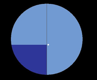
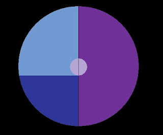
Follow along with this illustration of the globe. It will help.


We have not yet discussed longitude lines, but they are imaginary lines which run north and south around the circumference of the globe, intersecting both poles. Don't worry yet about how they're measured, or from where; that will come later. For now, just understand that they are lines which run along the circumference of the globe, from one pole to the other.

In our illustration there are two lines of longitude shown, at an angle of about 70° apart from each other.

It is clear (I hope) from the illustration that each of the longitude lines intersects the equator at a 90° angle. This happens to be true for all longitude lines.

Also shown is another latitude line north of the equator, which is also intersected by each of the longitude lines at a 90° angle.

All latitude lines are parallel to the equator. Since the equator and the other latitude line are parallel to each other, and the two longitude lines are intersecting both the equator and the other latitude line at the same angle, the two longitude lines are by definition also parallel to each other.

If we draw a triangle with two of the legs extending down our two longitude lines from the north pole down to the equator, and then for our third leg connect these two legs along the equator, we see two interesting things.


The first is that the three angles of the triangle are 90°, 90° and 70°, which, if added together, equal 250°.

The second is that our two longitude lines, which have been demonstrated to be parallel to each other, must necessarily converge and intersect at the north pole.

Very Important Concept: Two parallel lines often intersect, and the sum of the three angles of a triangle must always be greater than 180°.


It is possible that at some point in your education you were told something which was somewhat contrary to this. If you are somewhat surprised to learn that parallel lines intersect, and that the sum of the three angles of a triangle may never equal 180°, you are to be forgiven. Your high school geometry teacher, however, is not. A geometry teacher should know better. It happens that many of them don't.

If you happen to be of an age where you have not yet been exposed to the wonders of Euclidean geometry, never fear; at some point in your schooling, you will be. And on that golden, sunny day, listen politely while your teacher explains that two parallel lines can never intersect, and that the sum of the three angles of a triangle must always equal 180°. Once they are finished, please raise your hand. When you are called upon, please politely explain to your teacher that while their lecture was positively delightful, it turns out that the world is round, like an orange, or a bowling ball.

They love that.

The point of this exercise is to illustrate that solving a triangle on a spherical surface is, frankly, not making mud-pies. In some twenty-plus years of teaching celestial navigation I've had maybe two or three students who were comfortable solving spherical trigonometry with a scientific calculator, and not a single one who could solve it long-hand without a scientific calculator. Don't worry, nobody will expect you to; we have logarithmic tables or programmable calculators to solve the triangles for us. But this is why we need the logarithmic tables in the first place.

We'll see some of these soon. But our next topic will be looking at how we use this triangle to derive our celestial line of position.

Friday, September 16, 2011

Celestial Navigation 101: Lesson 2, Azimuth Intercept Method

In our last lesson we demonstrated how to derive one's position on a globe, using the distances from the points on the earth directly below three celestial bodies.

However, we do not navigate on globes. We navigate on flat pieces of paper (or computer screens) which represent only the tiniest fraction of the surface of the globe. In all but the rarest of cases, the Geographic Position of the celestial body isn't even on the chart we're navigating on. So how does one go about plotting a circle of equal altitude on a chart, when the point the circle is centered on isn't on the chart, or even on the boat?

The bad news is, you can't. The good news is, you don't have to.

This particular problem, by the way, troubled navigators for decades. Marcq St Hilaire discovered one solution to this problem which we still use today.

St Hilaire's solution was actually a fairly simple one. Previous navigators had sought to be able to determine their location "cold", without any idea of where they were before they derived the location. St Hilaire realized that while this was an interesting thought-problem, it wasn't relevant to the way vessels at sea are actually navigated. In actual navigation, you always have some idea of where the vessel is, by dead reckoning (which will be covered in detail in a later lesson) if by no other means.

If you have an assumed location, even if that assumption is wildly erroneous, then instead of measuring the distance from the Geographical Position of the celestial body, you simply calculate the altitude of the body as it would be from that Assumed Position (AP), and then compare that calculated altitude with the actual altitude which was observed and measured with your sextant.


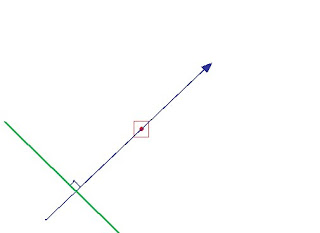
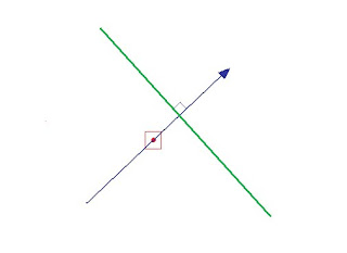
If your computed altitude of the body is a greater number than the observed altitude, you must be further away from the body by whatever amount the difference is. Remember that 1' of arc is one nautical mile. So, for example, if I compute the altitude of a body to be 46° 22', and then I observe the altitude to be 46° 08', then I have to be 14 nautical miles further away from the body than I thought I was. A mnemonic for this CGA (Coast Guard Academy), which stands for Computed Greater Away. If the Height Computed (Hc) is greater than the Height Observed (Ho) then your Line of Position (LOP) is moved away from the direction of the body, from your Assumed Position. This difference is called the Intercept, and it is from this that we get the name Azimuth Intercept Method. It is our primary method of celestial navigation. Note that the circles of equal altitude are so large that we can simply plot the segment of it which is closest to us as a straight line. Plotted on a chart or plotting sheet, our observation looks like this:


The red dot inside the red square is your Assumed Position on the chart.

The blue arrow is in the direction of the Azimuth (Zn) of the celestial body from your Assumed Position. Azimuth is just an astronomical word meaning "bearing" or "direction". In this case the azimuth is about 045° True, or roughly north-east. This is the direction you were facing when you observed the celestial body with your sextant.

The green line, which is perpendicular to the azimuth line, is however many minutes (nautical miles) distant from your Assumed Position as was the difference between your Height Computed and your Height Observed. In this case, because the computed height was greater than the observed height, it is further away from your assumed position than the celestial body. This green line is your Line of Position. You are actually somewhere along this line, as opposed your assumed position.

If your observed height had been greater than your computed height, it would have looked more like this:


If your Height Observed (Ho) is more than your Height Computed (Hc), your Line of Position must be closer toward the celestial body than your assumed position. Ho More Toward; HoMoTo. I've heard a number of different mnemonics for this, none of which are particularly politically correct.

Plotted on a chart or plotting sheet, this line of position looks something like this:


And you are somewhere on that line of position, rather than at your assumed position.

Now, do this with two more celestial objects, for a total of three lines of position:


Where the three green lines of position cross, labeled in this case with a black dot inside a small black circle, is your fix. This is the position of your vessel at the time you observed the three celestial bodies. If you were actually navigating, you would now update your dead reckoning track to this fix.

This plotted fix frankly looks like a mess. That's just what it is, and that's just what your fixes will look like.

In the next lesson, we will begin to see how the height and azimuth of the celestial body are computed.