 | |||||
| Illustration from NASA, so I didn't have to render it in MS Paint! |
It happens that for most of the 20th century, the poles moved at a fairly constant rate of about 10 km per year. However, for the past decade this rate has been steadily increasing; right now it is traveling northward at more than 55 km per year, and still accelerating. At the same time, the overall strength of the earth's magnetic field has decreased some 13% since 1900. Does all of this mean that the earth's magnetic poles are about to "flip"? Possibly, but there are other explanations as well. If it is, then the process will take hundreds of years, and the worst outcome is that during the time of magnetic minimum we may experience significantly more solar and cosmic radiation than normal, which may not go well for people of European descent but will otherwise hardly be catastrophic. The last magnetic field reversal happened 780,000 years ago, geologically speaking in the very recent past, our homo erectus ancestors survived it just fine.
Regardless of whether or not this proves to be the beginning of a field reversal, from a navigation standpoint it means that the magnetic variation printed on our charts is basically useless if the chart happens to be more than a year or so old.
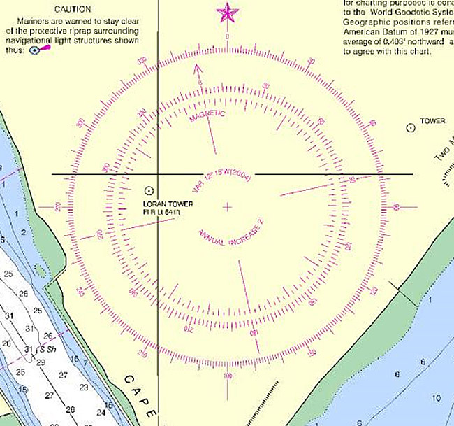
For example, in the illustration above the variation (hikers call it "declination", but it's the same thing) is listed as 12° 15'W in 2004, with an annual increase of 2'. It's 2011 now, so 7 years times 2' is 14' added to the 2004 variation, or 12° 29'. Once upon a time, we actually figured variation this way. Now we can't, because that 2' per year increase is just a wild guess. This isn't trivial. As an experiment I took some ten-year-old charts with me the last time I went up the Inside Passage, and had I relied on the printed annual variation corrections my variation would have been wrong by 3° - 5°, more than plenty to run aground in the fog.
Moral of the story is, before leaving on a major trip, buy new charts, and get Print-on-Demand so the variation is as up to date as possible.
Here's the full article from NASA .
On the same topic, here's a more recent article from Scientific American .
No comments:
Post a Comment